
This entry focuses on a part of our earlier discussion, Understanding Location Data. For greater context on what we will be addressing, please read that post first.
One of the more confusing aspects of the Public Land Survey System (PLSS) is the concept of “townships.” A “township” can refer to two different things. Both are part of the PLSS measurement system but have different uses. To know which township is being referenced requires some context.
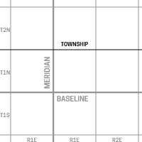
PIC 1: Township line running parallel to the baseline.
Township Lines
One type of township refers to a line that runs parallel to the baseline (east to west). When surveying a section of land, it divided into a grid. Surveyors start by assigning one main line running north to south (the Meridian) and one line running east to west (the Baseline). From that baseline, a series of parallel township lines (normally 6 miles apart) are drawn above and below the baseline to divide the land into horizontal strips similar to latitude lines. This way, surveyors can refer to a number of townships to describe how far above or below the meridian a piece of land can be found.
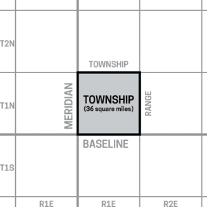
PIC 2: Township square, defined by bordering township and range lines.
Township Squares
Another type of township refers to a square parcel of land, generally 36 square miles. These squares of land are defined by a grid that is formed when the township lines (described above) cross range lines (which run north to south). Since both township and range lines are spaced about 6 miles from each other, the township square is (on average) 36 miles square. Claims can be described as being inside of one of these township squares.
Telling the difference*
Aside from context or some indication that a township is a square or a line, another way to tell the difference is looking at the township name. A shorter township name refers to township lines. The township line in PIC 1 would be called “T1N”. “T1N” refers to a Township line that is the 1st township line North of the baseline. Township lines are a higher level measurement and don’t require the same amount of information to describe them.
On the other hand, a square township has a longer name. This name is defined by the township and range lines that border it’s farthest sides from the baseline and meridian. So, a township square could be on the township line from before, “T1N” but will have the additional range descriptor. The township in PIC 2 would be called “T1N R1E”. That township covers land that is between the baseline and the 1st north township line and between the meridian and 1st east range line. As a comparison: township “T2S R5W” would contain the land between the 1st and 2nd south township lines and between the 4th and 5th west range lines.
In terms of context, township lines are usually as a form of measurement while township squares are used to describe a plot of land in which something else is contained.
Township Pages
Some users of The Coal Fields may have noticed that we now have township pages. These pages refer to the square townships and list mining claims that fall within that township. As townships are smaller than counties, this allows for a greater degree of specificity when defining the location of your claim.
Learn more about the history of townships on wikipedia: Township (United States)
*Note: another form of township that little to do with the PLSS is the civic township. These are part of local government administration and voting purposes. While the outlines of civic townships in the west often were originally based on the preexisting PLSS townships, these serve different purposes and can change in ways that survey townships do not.