
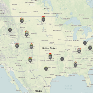
The time has come for a over of our mapping services to clear the way for further development of handy tools for our users. As such, this month we have rolled out a new map format to better allow our users to quickly peruse coal mining leases by disposition. In order to keep the maps as clutter free as possibly,…
Tag: location data
Understanding Townships
This entry focuses on a part of our earlier discussion, Understanding Location Data. For greater context on what we will be addressing, please read that post first. One of the more confusing aspects of the Public Land Survey System (PLSS) is the concept of “townships.” A “township” can refer to two different things. Both are part of the PLSS measurement system but have…